Discussion:
Did Amennakhte know which way was south to the source of the Nile ?
(too old to reply)
kangarooistan
2009-04-29 13:27:39 UTC
Permalink
Of course he did , he was the most respected scholar in Egypt in his
day , so WHY do we assume he did not know ,and drew the most famous
detailed map upside down

TOPOGRAPHIC AND GEOLOGIC CONTENT OF THE MAP
Loading Image...
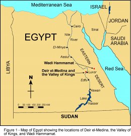
note south appears at top of Ancient Egyptian maps

The Turin papyrus map is notable for being the only
topographic map to survive from ancient Egypt and also for being one
of the earliest maps in the world with real geographic content.
Although there are a few older topographic maps from outside Egypt,
they are all quite crude and rather abstract in comparison to the
relatively modern-looking map drawn on the Turin papyrus. This map
shows a 15 km stretch of Wadi Hammamat (‘Valley of Many Baths’) in the
central part of Egypt’s Eastern Desert (Figure 1).
=============================================================
The top is oriented toward the south and the source of the Nile River
with west on the right side , and east to the sea is left.

Its confusing for the modern eye to reverse the map , hence my claim
the famous " gold mine ' depicted is not in Egypt , as it was made he
by the most famous Egyptologist of his day and he was an eye witness
and no fool , he knew which way was to the sea and which way was south
[ top ]

This is PROOF the gold mine pictured is NOT in Egypt , two roads
marked as going to the sea are going in the wrong direction

Number1 Translation


1 the road that leads to the sea


2 another road that leads to the sea
==============================================================
There is no constant scale used on the map, but by comparison with
the actual distances in Wadi Hamamat it is evident that the scale
varies between 50 and 100 m for each 1 cm on the map.

The map of interest " the gold mine "
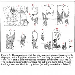
sections A to d cover about 75 x 45 cm

About 7500 x 4500 meters max , perhaps half that

The Turin Papyrus is reported to be a 2 meters long mining map

I claim the left hand section , is different and unrelated to the
rest , it even looks different , I only hold interest in section
marked A , but B , C and D are probable from the same map often
refered to as ' The Gold mine " from the written messages it
contains , the rest are of no interest to me as they refer to mining
stone

the original fragments identified , only the first 4 interest me
Loading Image...
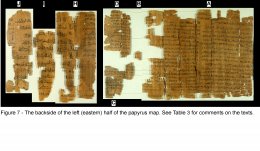
There is writing on the reverse that maybe totally unrelated
recycling of the old maps , of no interest to me ?
Loading Image...
I claim I know a site that fits the map on the left , in every
detail, and the buildings , roads ,river , hills and valleys and the
features near the center , as marked , are identifiable still ,The
Turin Papyrus looks as if It was an artists reconstruction drawn
very recently

it is NOT in Egypt

It is in South Australia

Yes I know you have heard this sort of claim before

but if you keep an open mind and examine the FACTS , they claim
there is a site in Egypt , I claim the site is in South Australia

One of us is wrong , the sites can be examined , If it fits like a
glove on this end , in minute detail and there is no site in Egypt
that even closely fits its worth digging around a bit to ask WHY

Once both sites are EXAMINED , then laugh at why nobody noticed
before , the far left map is different to the rest , why assume the
section at the start / left / fragments A, B, C and D are the same
area as the other sections , they have nothing in common but mining ,
and i dont recognize them

Turin papyrus in color with description
http://www.eeescience.utoledo.edu/Faculty/Harrell/Egypt/Turin%20Papyrus/Harrell_Papyrus_Map_text.htm

Turin papyrus computer image
Loading Image...

The Egyptian Topographic map of the site
Loading Image...
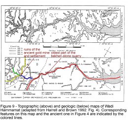
.
the Egyptian site with scripts numbered and laid out on the
topographic map
http://www.eeescience.utoledo.edu/Faculty/Harrell/Egypt/Turin%20Papyrus/Harrell_Papyrus_Map_fig-9.jpg
.
Table 1: Translations of the hieratic texts on the map side of the
Turin papyrus (adapted from Harrell and Brown 1992: Table 1)
http://www.eeescience.utoledo.edu/Faculty/Harrell/Egypt/Turin%20Papyrus/Harrell_Papyrus_Map_table-1.htm

______________________________________________________________

Text

Number1 Translation


1 the road that leads to the sea


2 another road that leads to the sea


3 the road of Tent-p-mer [the translation of the last word
is uncertain –

it may be the name of an unknown locality or it may mean ‘treasurer’
or ‘harbor’]


4 mountains of gold


5 mountains of gold


6 the houses of the gold-working settlement


7 cistern [or ‘water reservoir’; the text is written
on top of the water sign]


8 stela of Menma’atre, life, health and prosperity! [king
Sety I, 1290-1279 BC,

of the New Kingdom’s 19th Dynasty]2


9 the road of Ta-menti [the last word is apparently the
name of an unknown locality]


10 the shrine of Amun of the pure mountain


11 the mountains in which gold is worked, they are
colored pink


12 mountains of gold and silver [or perhaps ‘mountains of
electrum’, where electrum is a natural mixture of gold and silver]=
green gold
http://en.wikipedia.org/wiki/Gold#Color_of_gold


13 …the hill of Amun


14 the hill where Amun rests


15 [not translatable; appears to be part of a name for
some locality]


16 [too fragmentary to translate, but it appears to be
comments on travel from one unnamed locality to another; a travel
time of ‘one day’ and ‘gold’ are mentioned]


16’ mountains of gold [appears to be a continuation of 16 but
is a separate text]


17 distance from the gold-working settlement to the mountain
of bekheny,…khet

[this text is repeated three times, apparently for emphasis; the
distance in units of khet is missing]3,4

Besides being a topographic map of surprisingly modern aspect, the
Turin papyrus is also a geologic map because it accurately shows the
geographic distribution of different rock types (the black hills with
Hammamat siliciclastics, and the pink hills with Dokhan volcanics,
Atalla serpentinite and Fawakhir granite) and the lithologically
diverse wadi gravel (the brown, green and white dots within the main
valley that represent different kinds of rocks), and it also contains
information on quarrying and mining (see Table 2 for a description of
the geologic units).

Additionally notable are the representation of iron-stained, gold-
bearing quartz veins with three radiating bands on the pink hill above
the gold-mining settIement on fragment A (beneath text 5), and text 11
on fragment A, which reads very much like a legend on modern geologic
maps by explaining what the pink coloring represents.

The Turin papyrus is the oldest known geologic map in the world and
it is all the more remarkable considering that it would be another
2900 years before the next geologic map was made and this was in
France during the mid-1700’s.

There is no reason to think, however, that the ancient author
intentionally set out to make a geologic map. From the colors used for
the hills and wadi gravel, it is evident that he merely drew what he
literally saw in the desert – the real hills and surface gravels have
the same general colors as those on the map (Table 2).


THE MAP’S AUTHOR AND PURPOSE

The map was made about 1150 BC by the well-known ‘Scribe of the Tomb‘
Amennakhte, son of Ipuy (Figure 11).

Although Amennakhte did not sign his name to the map, it is clear
that he is its author. There are two pieces of evidence that support
this identification.

First, the text on the map side is in Amennakhte’s distinctive
handwriting, which is well known to Egyptologists who have studied his
many other writings. And second, the first and earliest text on the
backside of the papyrus (the first one listed in Table 3) was written
and signed by Amennakhte. It is not at all surprising that Amennakhte
would have made the map


and have spent many decades examining the very unusual features at
this site ,every year growing more and more convinced it is indeed a
VERY large , VERY old mine site , predating European settlement by a
VERY long time
I just stumbled , on this old Egyptian map and my jaw dropped
I thought it was a joke
I could have drawn it YESTERDAY
Do you know anybody who has examined the mine in Egypt ???
Its a mirror image of the site in South Australia , hard to imagine
such identical natural and man made features being so similar ,
considering its nature who makes the site

There can be no doubt at all on my end , this IS a map of a mine site
in South Australia

This map called the Turin Papyrus the far left panel , is indeed in
South Australia

Do laugh too loud , Im 100% sure , but I know you need more
evidence , that WILL take a while but ,

WATCH THIS SPACE

kanga
======
Jack Linthicum
2009-04-30 09:41:19 UTC
Permalink
Post by kangarooistan
Of course he did , he was the most respected scholar in Egypt in his
day , so WHY do we assume he did not know ,and drew the most famous
detailed map upside down
TOPOGRAPHIC AND GEOLOGIC CONTENT OF THE MAPhttp://www.eeescience.utoledo.edu/Faculty/Harrell/Egypt/Turin%20Papyr...
note south appears at top of Ancient Egyptian maps
            The Turin papyrus map is notable for being the only
topographic map to survive from ancient Egypt and also for being one
of the earliest maps in the world with real geographic content.
Although there are a few older topographic maps from outside Egypt,
they are all quite crude and rather abstract in comparison to the
relatively modern-looking map drawn on the Turin papyrus. This map
shows a 15 km stretch of Wadi Hammamat (‘Valley of Many Baths’) in the
central part of Egypt’s Eastern Desert (Figure 1).
=============================================================
 The top is oriented toward the south and the source of the Nile River
with west on the right side  , and east to the sea is left.
Its confusing for the modern eye to reverse the map , hence my claim
the famous " gold mine ' depicted  is not in Egypt , as it was made he
by the most famous Egyptologist of his day and he was an eye witness
and no fool , he knew which way was to the sea and which way was south
[ top ]
 This is PROOF the gold mine pictured is NOT in Egypt , two roads
marked as going to the sea are going in the wrong direction
Number1  Translation
     1            the road that leads to the sea
     2            another road that leads to the sea
==============================================================
 There is no constant scale used on the map, but by comparison with
the actual distances in Wadi Hamamat it is evident that the scale
varies between 50 and 100 m for each 1 cm on the map.
The map of interest " the gold mine "
sections A to d cover  about 75 x 45 cm
About 7500 x 4500 meters max , perhaps half that
 The Turin Papyrus is reported to be a 2 meters long mining map
 I claim the left hand section ,  is different and unrelated to the
rest , it even looks different , I only hold interest in section
marked A , but B , C and D  are probable from the same map  often
refered to as  ' The Gold mine " from the written messages it
contains ,  the rest are of no interest to me as they refer to mining
stone
the original fragments identified , only the first 4 interest mehttp://www.eeescience.utoledo.edu/Faculty/Harrell/Egypt/Turin%20Papyr...
There is writing on the reverse that maybe totally  unrelated
recycling of the old maps , of no interest to me ?http://www.eeescience.utoledo.edu/Faculty/Harrell/Egypt/Turin%20Papyr...
 I claim I know a site that fits the map on the left , in every
detail, and the buildings , roads ,river , hills and valleys  and the
features near the center  , as  marked , are  identifiable still ,The
Turin Papyrus  looks  as if It was  an artists reconstruction drawn
very recently
 it is NOT in Egypt
 It is in South Australia
 Yes I know you have heard this sort of claim before
 but  if you keep an open mind and examine the FACTS , they claim
there is a  site in Egypt  , I claim the site is in South Australia
 One of us is wrong , the sites can be examined , If it fits like a
glove on this end ,  in minute detail and there is no site in Egypt
that even closely fits its worth digging around a bit to ask WHY
 Once both sites are EXAMINED , then laugh at why nobody noticed
 before , the far left map is different to the rest , why assume the
section at the start / left / fragments  A, B, C and D  are the same
area as the other sections , they have nothing in common but mining ,
and i dont recognize them
Turin papyrus  in color with descriptionhttp://www.eeescience.utoledo.edu/Faculty/Harrell/Egypt/Turin%20Papyr...
Turin papyrus computer imagehttp://www.eeescience.utoledo.edu/Faculty/Harrell/Egypt/Turin%20Papyr...
The Egyptian Topographic map of the sitehttp://www.eeescience.utoledo.edu/Faculty/Harrell/Egypt/Turin%20Papyr...
.
the Egyptian site with scripts  numbered  and laid out on the
topographic maphttp://www.eeescience.utoledo.edu/Faculty/Harrell/Egypt/Turin%20Papyr...
.
Table 1: Translations of the hieratic texts on the map side of the
Turin  papyrus (adapted from Harrell and Brown 1992: Table 1)http://www.eeescience.utoledo.edu/Faculty/Harrell/Egypt/Turin%20Papyr...
______________________________________________________________
   Text
Number1  Translation
     1            the road that leads to the sea
     2            another road that leads to the sea
3            the road of Tent-p-mer [the translation of the last word
is uncertain –
it may be the name of an unknown locality or it may mean ‘treasurer’
or ‘harbor’]
     4            mountains of gold
     5            mountains of gold
     6            the houses of the gold-working settlement
     7            cistern [or ‘water reservoir’; the text is written
on top of the water sign]
8            stela of Menma’atre, life, health and prosperity! [king
Sety I, 1290-1279 BC,
of the New Kingdom’s 19th Dynasty]2
9            the road of Ta-menti [the last word is apparently the
name of an unknown locality]
     10          the shrine of Amun of the pure mountain
     11          the mountains in which gold is worked, they are
colored pink
12          mountains of gold and silver [or perhaps ‘mountains of
electrum’, where electrum is a natural mixture of gold and silver]=
green goldhttp://en.wikipedia.org/wiki/Gold#Color_of_gold
     13          …the hill of Amun
     14          the hill where Amun rests
     15          [not translatable; appears to be part of a name for
some locality]
16          [too fragmentary to translate, but it appears to be
comments on travel from one  unnamed locality to another; a travel
time of  ‘one day’ and ‘gold’ are mentioned]
16’         mountains of gold [appears to be a continuation of 16 but
is a separate text]
17          distance from the gold-working settlement to the mountain
of bekheny,…khet
[this text is repeated three times, apparently for emphasis; the
distance in units  of khet is missing]3,4
 Besides being a topographic map of surprisingly modern aspect, the
Turin papyrus is also a geologic map because it accurately shows the
geographic distribution of different rock types (the black hills with
Hammamat siliciclastics, and the pink hills with Dokhan volcanics,
Atalla serpentinite and Fawakhir granite) and the lithologically
diverse wadi gravel (the brown, green and white dots within the main
valley that represent different kinds of rocks), and it also contains
information on quarrying and mining (see Table 2 for a description of
the geologic units).
  Additionally notable are the representation of iron-stained, gold-
bearing quartz veins with three radiating bands on the pink hill above
the gold-mining settIement on fragment A (beneath text 5), and text 11
on fragment A, which reads very much like a legend on modern geologic
maps by explaining what the pink coloring represents.
   The Turin papyrus is the oldest known geologic map in the world and
it is all the more remarkable considering that it would be another
2900 years before the next geologic map was made and this was in
France during the mid-1700’s.
   There is no reason to think, however, that the ancient author
intentionally set out to make a geologic map. From the colors used for
the hills and wadi gravel, it is evident that he merely drew what he
literally saw in the desert – the real hills and surface gravels have
the same general colors as those on the map (Table 2).
THE MAP’S AUTHOR AND PURPOSE
The map was made about 1150 BC by the well-known ‘Scribe of the Tomb‘
Amennakhte, son of Ipuy (Figure 11).
  Although Amennakhte did not sign his name to the map, it is clear
that he is its author. There are two pieces of evidence that support
this identification.
   First, the text on the map side is in Amennakhte’s distinctive
handwriting, which is well known to Egyptologists who have studied his
many other writings.   And second, the first and earliest text on the
backside of the papyrus (the first one listed in Table 3) was written
and signed by Amennakhte. It is not at all surprising that Amennakhte
would have made the map
and have spent many decades examining the very unusual features at
this site ,every year growing more and more convinced it is indeed a
VERY large ,  VERY old mine site , predating European settlement by a
VERY long time
I just stumbled ,  on this old Egyptian map and my jaw dropped
I thought it was a joke
I could have drawn it YESTERDAY
Do you know anybody who has examined the mine in Egypt ???
 Its a mirror image of the site in South Australia , hard to imagine
such identical natural and man made features being so similar ,
considering its nature who makes the site
 There can be no doubt at all on my end , this IS a map of a mine site
in South Australia
 This map called the Turin Papyrus the far left panel ,  is indeed in
South Australia
 Do laugh too loud , Im 100% sure , but I know you need more
evidence , that WILL take a while but ,
  WATCH THIS SPACE
 kanga
 ======
Aspect is local, many maps have different orientations, certainly
having the "top" of the Nile at the top of the map makes more sense
than the reverse.
kangarooistan
2009-05-01 15:26:43 UTC
Permalink
Post by Jack Linthicum
Post by kangarooistan
Of course he did , he was the most respected scholar in Egypt in his
day , so WHY do we assume he did not know ,and drew the most famous
detailed map upside down
TOPOGRAPHIC AND GEOLOGIC CONTENT OF THE MAPhttp://www.eeescience.utoledo.edu/Faculty/Harrell/Egypt/Turin%20Papyr...
note south appears at top of Ancient Egyptian maps
            The Turin papyrus map is notable for being the only
topographic map to survive from ancient Egypt and also for being one
of the earliest maps in the world with real geographic content.
Although there are a few older topographic maps from outside Egypt,
they are all quite crude and rather abstract in comparison to the
relatively modern-looking map drawn on the Turin papyrus. This map
shows a 15 km stretch of Wadi Hammamat (‘Valley of Many Baths’) in the
central part of Egypt’s Eastern Desert (Figure 1).
=============================================================
 The top is oriented toward the south and the source of the Nile River
with west on the right side  , and east to the sea is left.
Its confusing for the modern eye to reverse the map , hence my claim
the famous " gold mine ' depicted  is not in Egypt , as it was made he
by the most famous Egyptologist of his day and he was an eye witness
and no fool , he knew which way was to the sea and which way was south
[ top ]
 This is PROOF the gold mine pictured is NOT in Egypt , two roads
marked as going to the sea are going in the wrong direction
Number1  Translation
     1            the road that leads to the sea
     2            another road that leads to the sea
==============================================================
 There is no constant scale used on the map, but by comparison with
the actual distances in Wadi Hamamat it is evident that the scale
varies between 50 and 100 m for each 1 cm on the map.
The map of interest " the gold mine "
sections A to d cover  about 75 x 45 cm
About 7500 x 4500 meters max , perhaps half that
 The Turin Papyrus is reported to be a 2 meters long mining map
 I claim the left hand section ,  is different and unrelated to the
rest , it even looks different , I only hold interest in section
marked A , but B , C and D  are probable from the same map  often
refered to as  ' The Gold mine " from the written messages it
contains ,  the rest are of no interest to me as they refer to mining
stone
the original fragments identified , only the first 4 interest mehttp://www.eeescience.utoledo.edu/Faculty/Harrell/Egypt/Turin%20Papyr...
There is writing on the reverse that maybe totally  unrelated
recycling of the old maps , of no interest to me ?http://www.eeescience.utoledo.edu/Faculty/Harrell/Egypt/Turin%20Papyr...
 I claim I know a site that fits the map on the left , in every
detail, and the buildings , roads ,river , hills and valleys  and the
features near the center  , as  marked , are  identifiable still ,The
Turin Papyrus  looks  as if It was  an artists reconstruction drawn
very recently
 it is NOT in Egypt
 It is in South Australia
 Yes I know you have heard this sort of claim before
 but  if you keep an open mind and examine the FACTS , they claim
there is a  site in Egypt  , I claim the site is in South Australia
 One of us is wrong , the sites can be examined , If it fits like a
glove on this end ,  in minute detail and there is no site in Egypt
that even closely fits its worth digging around a bit to ask WHY
 Once both sites are EXAMINED , then laugh at why nobody noticed
 before , the far left map is different to the rest , why assume the
section at the start / left / fragments  A, B, C and D  are the same
area as the other sections , they have nothing in common but mining ,
and i dont recognize them
Turin papyrus  in color with descriptionhttp://www.eeescience.utoledo.edu/Faculty/Harrell/Egypt/Turin%20Papyr...
Turin papyrus computer imagehttp://www.eeescience.utoledo.edu/Faculty/Harrell/Egypt/Turin%20Papyr...
The Egyptian Topographic map of the sitehttp://www.eeescience.utoledo.edu/Faculty/Harrell/Egypt/Turin%20Papyr...
.
the Egyptian site with scripts  numbered  and laid out on the
topographic maphttp://www.eeescience.utoledo.edu/Faculty/Harrell/Egypt/Turin%20Papyr...
.
Table 1: Translations of the hieratic texts on the map side of the
Turin  papyrus (adapted from Harrell and Brown 1992: Table 1)http://www.eeescience.utoledo.edu/Faculty/Harrell/Egypt/Turin%20Papyr...
______________________________________________________________
   Text
Number1  Translation
     1            the road that leads to the sea
     2            another road that leads to the sea
3            the road of Tent-p-mer [the translation of the last word
is uncertain –
it may be the name of an unknown locality or it may mean ‘treasurer’
or ‘harbor’]
     4            mountains of gold
     5            mountains of gold
     6            the houses of the gold-working settlement
     7            cistern [or ‘water reservoir’; the text is written
on top of the water sign]
8            stela of Menma’atre, life, health and prosperity! [king
Sety I, 1290-1279 BC,
of the New Kingdom’s 19th Dynasty]2
9            the road of Ta-menti [the last word is apparently the
name of an unknown locality]
     10          the shrine of Amun of the pure mountain
     11          the mountains in which gold is worked, they are
colored pink
12          mountains of gold and silver [or perhaps ‘mountains of
electrum’, where electrum is a natural mixture of gold and silver]=
green goldhttp://en.wikipedia.org/wiki/Gold#Color_of_gold
     13          …the hill of Amun
     14          the hill where Amun rests
     15          [not translatable; appears to be part of a name for
some locality]
16          [too fragmentary to translate, but it appears to be
comments on travel from one  unnamed locality to another; a travel
time of  ‘one day’ and ‘gold’ are mentioned]
16’         mountains of gold [appears to be a continuation of 16 but
is a separate text]
17          distance from the gold-working settlement to the mountain
of bekheny,…khet
[this text is repeated three times, apparently for emphasis; the
distance in units  of khet is missing]3,4
 Besides being a topographic map of surprisingly modern aspect, the
Turin papyrus is also a geologic map because it accurately shows the
geographic distribution of different rock types (the black hills with
Hammamat siliciclastics, and the pink hills with Dokhan volcanics,
Atalla serpentinite and Fawakhir granite) and the lithologically
diverse wadi gravel (the brown, green and white dots within the main
valley that represent different kinds of rocks), and it also contains
information on quarrying and mining (see Table 2 for a description of
the geologic units).
  Additionally notable are the representation of iron-stained, gold-
bearing quartz veins with three radiating bands on the pink hill above
the gold-mining settIement on fragment A (beneath text 5), and text 11
on fragment A, which reads very much like a legend on modern geologic
maps by explaining what the pink coloring represents.
   The Turin papyrus is the oldest known geologic map in the world and
it is all the more remarkable considering that it would be another
2900 years before the next geologic map was made and this was in
France during the mid-1700’s.
   There is no reason to think, however, that the ancient author
intentionally set out to make a geologic map. From the colors used for
the hills and wadi gravel, it is evident that he merely drew what he
literally saw in the desert – the real hills and surface gravels have
the same general colors as those on the map (Table 2).
THE MAP’S AUTHOR AND PURPOSE
The map was made about 1150 BC by the well-known ‘Scribe of the Tomb‘
Amennakhte, son of Ipuy (Figure 11).
  Although Amennakhte did not sign his name to the map, it is clear
that he is its author. There are two pieces of evidence that support
this identification.
   First, the text on the map side is in Amennakhte’s distinctive
handwriting, which is well known to Egyptologists who have studied his
many other writings.   And second, the first and earliest text on the
backside of the papyrus (the first one listed in Table 3) was written
and signed by Amennakhte. It is not at all surprising that Amennakhte
would have made the map
and have spent many decades examining the very unusual features at
this site ,every year growing more and more convinced it is indeed a
VERY large ,  VERY old mine site , predating European settlement by a
VERY long time
I just stumbled ,  on this old Egyptian map and my jaw dropped
I thought it was a joke
I could have drawn it YESTERDAY
Do you know anybody who has examined the mine in Egypt ???
 Its a mirror image of the site in South Australia , hard to imagine
such identical natural and man made features being so similar ,
considering its nature who makes the site
 There can be no doubt at all on my end , this IS a map of a mine site
in South Australia
 This map called the Turin Papyrus the far left panel ,  is indeed in
South Australia
 Do laugh too loud , Im 100% sure , but I know you need more
evidence , that WILL take a while but ,
  WATCH THIS SPACE
 kanga
 ======
.
Post by Jack Linthicum
Aspect is local, many maps have different orientations, certainly
having the "top" of the Nile at the top of the map makes more sense
than the reverse.
Hi Jack
Indeed mate you are right , i visited the site again to test a few
measurements to try and work out the scale

Most fascinating

I was able to determine the map is a VIEW from the perspective of a
person near the management site of the mine,

it is to VISUAL SCALE as seen from this area as are ALL the
features , as seen from the management strip, that IS 750 meters long
straight road in the upper middle of the map and everything seen at
a distance is included as SEEN from here

hard to explain but very easy really once you stand at the top this
is EXACTLY what you see looking down over the mine sight


kanga
======
Jack Linthicum
2009-05-01 17:44:10 UTC
Permalink
Post by kangarooistan
Post by Jack Linthicum
Post by kangarooistan
Of course he did , he was the most respected scholar in Egypt in his
day , so WHY do we assume he did not know ,and drew the most famous
detailed map upside down
TOPOGRAPHIC AND GEOLOGIC CONTENT OF THE MAPhttp://www.eeescience.utoledo.edu/Faculty/Harrell/Egypt/Turin%20Papyr...
note south appears at top of Ancient Egyptian maps
            The Turin papyrus map is notable for being the only
topographic map to survive from ancient Egypt and also for being one
of the earliest maps in the world with real geographic content.
Although there are a few older topographic maps from outside Egypt,
they are all quite crude and rather abstract in comparison to the
relatively modern-looking map drawn on the Turin papyrus. This map
shows a 15 km stretch of Wadi Hammamat (‘Valley of Many Baths’) in the
central part of Egypt’s Eastern Desert (Figure 1).
=============================================================
 The top is oriented toward the south and the source of the Nile River
with west on the right side  , and east to the sea is left.
Its confusing for the modern eye to reverse the map , hence my claim
the famous " gold mine ' depicted  is not in Egypt , as it was made he
by the most famous Egyptologist of his day and he was an eye witness
and no fool , he knew which way was to the sea and which way was south
[ top ]
 This is PROOF the gold mine pictured is NOT in Egypt , two roads
marked as going to the sea are going in the wrong direction
Number1  Translation
     1            the road that leads to the sea
     2            another road that leads to the sea
==============================================================
 There is no constant scale used on the map, but by comparison with
the actual distances in Wadi Hamamat it is evident that the scale
varies between 50 and 100 m for each 1 cm on the map.
The map of interest " the gold mine "
sections A to d cover  about 75 x 45 cm
About 7500 x 4500 meters max , perhaps half that
 The Turin Papyrus is reported to be a 2 meters long mining map
 I claim the left hand section ,  is different and unrelated to the
rest , it even looks different , I only hold interest in section
marked A , but B , C and D  are probable from the same map  often
refered to as  ' The Gold mine " from the written messages it
contains ,  the rest are of no interest to me as they refer to mining
stone
the original fragments identified , only the first 4 interest mehttp://www.eeescience.utoledo.edu/Faculty/Harrell/Egypt/Turin%20Papyr...
There is writing on the reverse that maybe totally  unrelated
recycling of the old maps , of no interest to me ?http://www.eeescience.utoledo.edu/Faculty/Harrell/Egypt/Turin%20Papyr...
 I claim I know a site that fits the map on the left , in every
detail, and the buildings , roads ,river , hills and valleys  and the
features near the center  , as  marked , are  identifiable still ,The
Turin Papyrus  looks  as if It was  an artists reconstruction drawn
very recently
 it is NOT in Egypt
 It is in South Australia
 Yes I know you have heard this sort of claim before
 but  if you keep an open mind and examine the FACTS , they claim
there is a  site in Egypt  , I claim the site is in South Australia
 One of us is wrong , the sites can be examined , If it fits like a
glove on this end ,  in minute detail and there is no site in Egypt
that even closely fits its worth digging around a bit to ask WHY
 Once both sites are EXAMINED , then laugh at why nobody noticed
 before , the far left map is different to the rest , why assume the
section at the start / left / fragments  A, B, C and D  are the same
area as the other sections , they have nothing in common but mining ,
and i dont recognize them
Turin papyrus  in color with descriptionhttp://www.eeescience.utoledo.edu/Faculty/Harrell/Egypt/Turin%20Papyr...
Turin papyrus computer imagehttp://www.eeescience.utoledo.edu/Faculty/Harrell/Egypt/Turin%20Papyr...
The Egyptian Topographic map of the sitehttp://www.eeescience.utoledo.edu/Faculty/Harrell/Egypt/Turin%20Papyr...
.
the Egyptian site with scripts  numbered  and laid out on the
topographic maphttp://www.eeescience.utoledo.edu/Faculty/Harrell/Egypt/Turin%20Papyr...
.
Table 1: Translations of the hieratic texts on the map side of the
Turin  papyrus (adapted from Harrell and Brown 1992: Table 1)http://www.eeescience.utoledo.edu/Faculty/Harrell/Egypt/Turin%20Papyr...
______________________________________________________________
   Text
Number1  Translation
     1            the road that leads to the sea
     2            another road that leads to the sea
3            the road of Tent-p-mer [the translation of the last word
is uncertain –
it may be the name of an unknown locality or it may mean ‘treasurer’
or ‘harbor’]
     4            mountains of gold
     5            mountains of gold
     6            the houses of the gold-working settlement
     7            cistern [or ‘water reservoir’; the text is written
on top of the water sign]
8            stela of Menma’atre, life, health and prosperity! [king
Sety I, 1290-1279 BC,
of the New Kingdom’s 19th Dynasty]2
9            the road of Ta-menti [the last word is apparently the
name of an unknown locality]
     10          the shrine of Amun of the pure mountain
     11          the mountains in which gold is worked, they are
colored pink
12          mountains of gold and silver [or perhaps ‘mountains of
electrum’, where electrum is a natural mixture of gold and silver]=
green goldhttp://en.wikipedia.org/wiki/Gold#Color_of_gold
     13          …the hill of Amun
     14          the hill where Amun rests
     15          [not translatable; appears to be part of a name for
some locality]
16          [too fragmentary to translate, but it appears to be
comments on travel from one  unnamed locality to another; a travel
time of  ‘one day’ and ‘gold’ are mentioned]
16’         mountains of gold [appears to be a continuation of 16 but
is a separate text]
17          distance from the gold-working settlement to the mountain
of bekheny,…khet
[this text is repeated three times, apparently for emphasis; the
distance in units  of khet is missing]3,4
 Besides being a topographic map of surprisingly modern aspect, the
Turin papyrus is also a geologic map because it accurately shows the
geographic distribution of different rock types (the black hills with
Hammamat siliciclastics, and the pink hills with Dokhan volcanics,
Atalla serpentinite and Fawakhir granite) and the lithologically
diverse wadi gravel (the brown, green and white dots within the main
valley that represent different kinds of rocks), and it also contains
information on quarrying and mining (see Table 2 for a description of
the geologic units).
  Additionally notable are the representation of iron-stained, gold-
bearing quartz veins with three radiating bands on the pink hill above
the gold-mining settIement on fragment A (beneath text 5), and text 11
on fragment A, which reads very much like a legend on modern geologic
maps by explaining what the pink coloring represents.
   The Turin papyrus is the oldest known geologic map in the world and
it is all the more remarkable considering that it would be another
2900 years before the next geologic map was made and this was in
France during the mid-1700’s.
   There is no reason to think, however, that the ancient author
intentionally set out to make a geologic map. From the colors used for
the hills and wadi gravel, it is evident that he merely drew what he
literally saw in the desert – the real hills and surface gravels have
the same general colors as those on the map (Table 2).
THE MAP’S AUTHOR AND PURPOSE
The map was made about 1150 BC by the well-known ‘Scribe of the Tomb‘
Amennakhte, son of Ipuy (Figure 11).
  Although Amennakhte did not sign his name to the map, it is clear
that he is its author. There are two pieces of evidence that support
this identification.
   First, the text on the map side is in Amennakhte’s distinctive
handwriting, which is well known to Egyptologists who have studied his
many other writings.   And second, the first and earliest text on the
backside of the papyrus (the first one listed in Table 3) was written
and signed by Amennakhte. It is not at all surprising that Amennakhte
would have made the map
and have spent many decades examining the very unusual features at
this site ,every year growing more and more convinced it is indeed a
VERY large ,  VERY old mine site , predating European settlement by a
VERY long time
I just stumbled ,  on this old Egyptian map and my jaw dropped
I thought it was a joke
I could have drawn it YESTERDAY
Do you know anybody who has examined the mine in Egypt ???
 Its a mirror image of the site in South Australia , hard to imagine
such identical natural and man made features being so similar ,
considering its nature who makes the site
 There can be no doubt at all on my end , this IS a map of a mine site
in South Australia
 This map called the Turin Papyrus the far left panel ,  is indeed in
South Australia
 Do laugh too loud , Im 100% sure , but I know you need more
evidence , that WILL take a while but ,
  WATCH THIS SPACE
 kanga
 ======
.
Post by Jack Linthicum
Aspect is local, many maps have different orientations, certainly
having the "top" of the Nile at the top of the map makes more sense
than the reverse.
Hi Jack
Indeed mate you are right , i visited the  site again to test a few
measurements to try and work out the scale
Most fascinating
I was able to determine the map is a VIEW from the perspective of a
person near the management site of the mine,
 it is to VISUAL SCALE as seen from this area as are ALL the
features , as seen from the management strip,  that IS 750 meters long
straight road  in  the upper middle of the map and everything seen at
a distance is included as SEEN from here
hard to explain but very easy  really once you stand at the top this
is EXACTLY what you see looking down over the mine sight
kanga
======
The cite I gave you says there are at least two scales.
kangarooistan
2009-05-03 20:29:04 UTC
Permalink
Post by kangarooistan
Of course he did , he was the most respected scholar in Egypt in his
day , so WHY do we assume he did not know ,and drew the most famous
detailed map upside down
TOPOGRAPHIC AND GEOLOGIC CONTENT OF THE MAPhttp://www.eeescience.utoledo.edu/Faculty/Harrell/Egypt/Turin%20Papyr...
note south appears at top of Ancient Egyptian maps
            The Turin papyrus map is notable for being the only
topographic map to survive from ancient Egypt and also for being one
of the earliest maps in the world with real geographic content.
Although there are a few older topographic maps from outside Egypt,
they are all quite crude and rather abstract in comparison to the
relatively modern-looking map drawn on the Turin papyrus. This map
shows a 15 km stretch of Wadi Hammamat (‘Valley of Many Baths’) in the
central part of Egypt’s Eastern Desert (Figure 1).
=============================================================
 The top is oriented toward the south and the source of the Nile River
with west on the right side  , and east to the sea is left.
Its confusing for the modern eye to reverse the map , hence my claim
the famous " gold mine ' depicted  is not in Egypt , as it was made he
by the most famous Egyptologist of his day and he was an eye witness
and no fool , he knew which way was to the sea and which way was south
[ top ]
 This is PROOF the gold mine pictured is NOT in Egypt , two roads
marked as going to the sea are going in the wrong direction
Number1  Translation
     1            the road that leads to the sea
     2            another road that leads to the sea
==============================================================
 There is no constant scale used on the map, but by comparison with
the actual distances in Wadi Hamamat it is evident that the scale
varies between 50 and 100 m for each 1 cm on the map.
The map of interest " the gold mine "
sections A to d cover  about 75 x 45 cm
About 7500 x 4500 meters max , perhaps half that
 The Turin Papyrus is reported to be a 2 meters long mining map
 I claim the left hand section ,  is different and unrelated to the
rest , it even looks different , I only hold interest in section
marked A , but B , C and D  are probable from the same map  often
refered to as  ' The Gold mine " from the written messages it
contains ,  the rest are of no interest to me as they refer to mining
stone
the original fragments identified , only the first 4 interest mehttp://www.eeescience.utoledo.edu/Faculty/Harrell/Egypt/Turin%20Papyr...
There is writing on the reverse that maybe totally  unrelated
recycling of the old maps , of no interest to me ?http://www.eeescience.utoledo.edu/Faculty/Harrell/Egypt/Turin%20Papyr...
 I claim I know a site that fits the map on the left , in every
detail, and the buildings , roads ,river , hills and valleys  and the
features near the center  , as  marked , are  identifiable still ,The
Turin Papyrus  looks  as if It was  an artists reconstruction drawn
very recently
 it is NOT in Egypt
 It is in South Australia
 Yes I know you have heard this sort of claim before
 but  if you keep an open mind and examine the FACTS , they claim
there is a  site in Egypt  , I claim the site is in South Australia
 One of us is wrong , the sites can be examined , If it fits like a
glove on this end ,  in minute detail and there is no site in Egypt
that even closely fits its worth digging around a bit to ask WHY
 Once both sites are EXAMINED , then laugh at why nobody noticed
 before , the far left map is different to the rest , why assume the
section at the start / left / fragments  A, B, C and D  are the same
area as the other sections , they have nothing in common but mining ,
and i dont recognize them
Turin papyrus  in color with descriptionhttp://www.eeescience.utoledo.edu/Faculty/Harrell/Egypt/Turin%20Papyr...
Turin papyrus computer imagehttp://www.eeescience.utoledo.edu/Faculty/Harrell/Egypt/Turin%20Papyr...
The Egyptian Topographic map of the sitehttp://www.eeescience.utoledo.edu/Faculty/Harrell/Egypt/Turin%20Papyr...
.
the Egyptian site with scripts  numbered  and laid out on the
topographic maphttp://www.eeescience.utoledo.edu/Faculty/Harrell/Egypt/Turin%20Papyr...
.
Table 1: Translations of the hieratic texts on the map side of the
Turin  papyrus (adapted from Harrell and Brown 1992: Table 1)http://www.eeescience.utoledo.edu/Faculty/Harrell/Egypt/Turin%20Papyr...
______________________________________________________________
   Text
Number1  Translation
     1            the road that leads to the sea
     2            another road that leads to the sea
3            the road of Tent-p-mer [the translation of the last word
is uncertain –
it may be the name of an unknown locality or it may mean ‘treasurer’
or ‘harbor’]
     4            mountains of gold
     5            mountains of gold
     6            the houses of the gold-working settlement
     7            cistern [or ‘water reservoir’; the text is written
on top of the water sign]
8            stela of Menma’atre, life, health and prosperity! [king
Sety I, 1290-1279 BC,
of the New Kingdom’s 19th Dynasty]2
9            the road of Ta-menti [the last word is apparently the
name of an unknown locality]
     10          the shrine of Amun of the pure mountain
     11          the mountains in which gold is worked, they are
colored pink
12          mountains of gold and silver [or perhaps ‘mountains of
electrum’, where electrum is a natural mixture of gold and silver]=
green goldhttp://en.wikipedia.org/wiki/Gold#Color_of_gold
     13          …the hill of Amun
     14          the hill where Amun rests
     15          [not translatable; appears to be part of a name for
some locality]
16          [too fragmentary to translate, but it appears to be
comments on travel from one  unnamed locality to another; a travel
time of  ‘one day’ and ‘gold’ are mentioned]
16’         mountains of gold [appears to be a continuation of 16 but
is a separate text]
17          distance from the gold-working settlement to the mountain
of bekheny,…khet
[this text is repeated three times, apparently for emphasis; the
distance in units  of khet is missing]3,4
 Besides being a topographic map of surprisingly modern aspect, the
Turin papyrus is also a geologic map because it accurately shows the
geographic distribution of different rock types (the black hills with
Hammamat siliciclastics, and the pink hills with Dokhan volcanics,
Atalla serpentinite and Fawakhir granite) and the lithologically
diverse wadi gravel (the brown, green and white dots within the main
valley that represent different kinds of rocks), and it also contains
information on quarrying and mining (see Table 2 for a description of
the geologic units).
  Additionally notable are the representation of iron-stained, gold-
bearing quartz veins with three radiating bands on the pink hill above
the gold-mining settIement on fragment A (beneath text 5), and text 11
on fragment A, which reads very much like a legend on modern geologic
maps by explaining what the pink coloring represents.
   The Turin papyrus is the oldest known geologic map in the world and
it is all the more remarkable considering that it would be another
2900 years before the next geologic map was made and this was in
France during the mid-1700’s.
   There is no reason to think, however, that the ancient author
intentionally set out to make a geologic map. From the colors used for
the hills and wadi gravel, it is evident that he merely drew what he
literally saw in the desert – the real hills and surface gravels have
the same general colors as those on the map (Table 2).
THE MAP’S AUTHOR AND PURPOSE
The map was made about 1150 BC by the well-known ‘Scribe of the Tomb‘
Amennakhte, son of Ipuy (Figure 11).
  Although Amennakhte did not sign his name to the map, it is clear
that he is its author. There are two pieces of evidence that support
this identification.
   First, the text on the map side is in Amennakhte’s distinctive
handwriting, which is well known to Egyptologists who have studied his
many other writings.   And second, the first and earliest text on the
backside of the papyrus (the first one listed in Table 3) was written
and signed by Amennakhte. It is not at all surprising that Amennakhte
would have made the map
and have spent many decades examining the very unusual features at
this site ,every year growing more and more convinced it is indeed a
VERY large ,  VERY old mine site , predating European settlement by a
VERY long time
I just
...
read more »
Hi Jack

Itsnow down to a simple examination of the sites

i have examined and measured the South Australian site and fine ever
more evidence every time and every feature that I tesyt fits EXACTLY
as laid out on the plan

When viewed from the position marked with the Stele at the entrance to
the mine from the top road from the sea at mine left

The scale is EXACTLY as seen from this site , almost like a
photograph

I am unable to test the paint / oches used on the Turin Papyrus but I
actulaally sispect even the added color is made from the actual rocks
in this mine to EXACTLY represent the site in TRUE color AS SEEN in
everydetail

I can not test this , but such is the level of detail it makes me
consider the person was sitting 30 feet in the air with a camera and
local minerals ground to powder as paint

DONT LAUGH MATE

There is nil doubt the mine is indeed in South Australia

The Turin Papyrus does exist and so do two mine sites

Its simply a matter of time till the three are measured , and the
facts compared

There is Nil doubt in my mind , as more and more evidence mounts with
every visit , its a vast site , with a management road of 750 meters
at the top of the mine with all the important infrastructure as shown
on the map , with the actual mine disappearing into the distance , yet
appearing at the bottom of the map ,

sounds silly , but that's what map shows , I can not describe all the
detail , its now over whelming, so those interested will need to await
a number of experts opinions , little more can be had online as minute
detail needs to be viewed and tested , no easy option to over turn
this much history without several experts agreeing

Not sure who or how , but I will find some way to establish the
matters, its not opinion but facts on the ground that will decide

Thanks for your help and inputs jack , I can not offer more detail
just yet , until i have more on ground examinations by independent
field examinations we are stuck playing a word game online

Not quite sure what to do next , but the mine and the map wont be
going any where so it matter not how long it takes , years or
decades , sooner or later My opinion will be fully tested against the
evidence and IF I am correct I can STILL claim to be the discoverer

that the Turin papyrus " gold mine " is in SOUTH AUSTRALIA definitely
not in Egypt at the site now claimed

AND the accuracy of the 3160 year old map is ASTONISHING in its detail
and accuracy FAR FAR more than presently thought

So much so that it will raise the NEXT question

WHY with so much detail did they not describe its location better or
was the evidence altered , or was the map looted from one of SETI 1st
conquests , in his 12 ? years of rule , as plunder booty or payment ,
by some other country who made the map , and the Egyptians simply
added their Hieroglyphs over the site map , there seems a reason the
location has been not made more clear , while the site is so well
described and depicted

Perhaps the Egyptians plundered the map but did NOT know where the
mine was ????

the site seems to be abandoned shortly after this map was made , such
as I can tell its so accurate

Mind you I suspect the mine was worked from centuries by the look of
the waste build up near the gold refining area , the refinery waste is
over 50 feet thick , 1000s of tons of refinery grade mine waste ,
material not in its natural place or form , it was my first clue ,
that vast ancient gold mining and refining had occurred long before
European settlement , and it IS exactly in place as described in the
Turin papyrus marked as gold refinery , exactly the correct distance
to the roads river and natural features described in EVERY detail

Its hard to explain 1000 plus tons of powdered Quartz and fire brick
clay any other way , AND HARD TO DISMISS


kanga
======

Loading...